
World
Snow west of Calgary Tuesday morning with frost advisories possible again overnight

As expected, cooler overnight temperatures in the region prompted frost advisories overnight and brought snow to areas west of Calgary.
Precipitation attached to a frontal system continued to produce rain early Tuesday with temperatures (mostly tied to elevation) dictating the rain vs. snow presentation at the surface.
As of 6:30 a.m, communities like Banff and Crowsnest Pass were reporting temperatures of 0 C and it was -2 C in Jasper.
Overnight cooling from Tuesday to Wednesday could mean a similar start on Wednesday with frost possible and mixed precipitation in higher elevation or low-lying areas.
This cooler weather in our area is one of the contributing factors for the heat dome across Central Canada and the Northeastern United States.
An Omega block is funneling warm air in from the Gulf and around a larger high pressure system. On either side there are anchoring lows – including the ones drawing colder air in to southern Alberta.
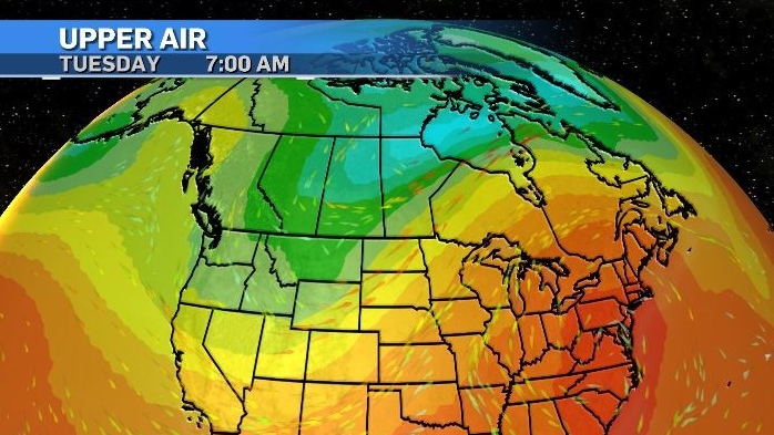
This block is not as balanced as the one that impacted the Prairies in 2021, so it is expected to break down and move east.
When that happens (later Wednesday) southern Alberta will see a return to warmer weather with daytime highs and overnight lows trending above seasonal until early next week.
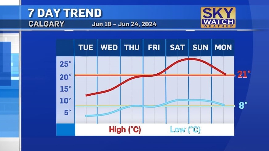
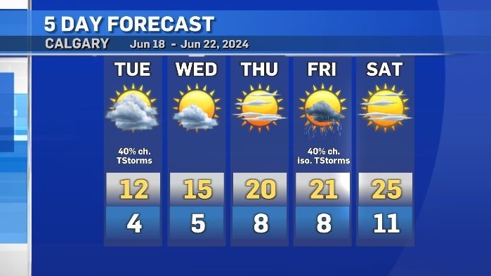
For Tuesday, there is a slight chance of scattered showers or some isolated thunderstorms throughout the region – including in Calgary. But the chance of any severe development remains unlikely.
Sunshine will return starting on Wednesday, and outside of a slight chance of rain on Friday – should stick around for the next five to seven days.

20/7/2024 Horse Racing Tips and Best Bets – Rosehill, Winter Challenge day
 "BCCI want Test specialists to play domestic cricket; Rohit, Virat, Bumrah to be exceptions")
BCCI want Test specialists to play domestic cricket; Rohit, Virat, Bumrah to be exceptions

HORSE RACING DAY 5: Andrew Champagne’s picks, analysis, bankroll
HORSE RACING DAY 5: Andrew Champagne’s picks, analysis, bankroll

600 Jobs, 25,000 Seekers: Air India Drive Sets Off Stampede Fear In Mumbai

More Trips, Higher Prices: Business Travel Spending May Finally Top 2019 Levels

Let’s take this offline: why indie fashion boutiques are back in fashion

Blue Jays balance college-heavy Draft with a few high-upside picks

Get to Know Gopher Men’s Basketball’s Frank Mitchell – University of Minnesota Athletics
