World
Last week’s storm in northern Ont. being investigated for tornado activity

The owner of a northern Ontario campground continues the cleanup after a powerful storm swept through the region last Thursday prompting severe weather and tornado warnings.
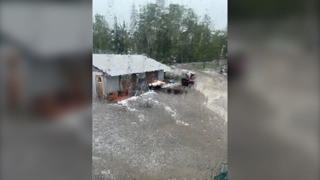
Trevor Graydon of Mowat Landing Cottages on the Montreal River in New Liskeard captured a video of the intense rain, hail and wind that pummelled his property, taking out his dock and knocking down several tall trees.
Experts with the Northern Tornadoes Project out of Western University said the damage appears to have been caused by a downburst.
“With a tornado, we’ve got air that’s coming into the bottom of the storm and then up … with a downburst, you’ve got air that’s starting in the storm and then falling out and spreading out. So it’s down and out rather than in and up,” David Sills, executive director of Northern Tornadoes Project, told CTVNewsNorthernOntario.ca in a video interview.
“With the video that you sent, all of the highest winds occurred while there was heavy rain and hail and it was kind of a longer event, several minutes. That’s typical of downbursts because they usually go for three, four, five maybe even longer minutes and they’re accompanied by heavy precipitation, including hail, so that the worst winds will come when it is just like a whiteout outside.”
Sills said tornadoes typically follow precipitation, rather than occurring at the same time, and dust and debris will be seen swirling around for just under a minute.
Storm damage is seen in New Liskeard, Ont., earlier this month. (Trevor Graydon/Mowat Landing Cottages)
Tornadoes in Canada
The Northern Tornadoes Project began in 2017 to get a better understanding of the weather phenomenon in Canada.
It brought Western University Engineering together with meteorological experts to study wind impacts.
Initially focusing on finding information on tornadoes in remote areas, it was so successful, they spread their research throughout the country.
“Now, we’re really doing all of the damage surveying after a damaging event right across the country, so we have a team that — several teams — that can go out anywhere in the country and do a damage survey on the ground and also using drones,” Sills said.
One of the biggest surprises that have come out of the study is the areas of Canada that see the most tornado activity, he said.
“Going into this project, we expected Saskatchewan to be the hot spot for tornadoes in the country and that really hasn’t happened,” Sills said.
“Alberta’s been busy, on the Prairies, and there’s been some big tornadoes that have happened in Manitoba, but most of the tornadoes have been in Ontario and a lot in Quebec, as well.”
 Storm damage in New Liskeard, Ont.
Using satellite imagery
Part of the investigative process of tracking tornadoes comes after the fact using satellites and is one of the reasons Sills said they are able to document more of them.
“So what we do is we have to wait a few days for clear skies and then look at high-resolution satellite imagery and then do the before-and-after comparison,” Sills said.
“Usually, when we do that, the tornado track will pop out very quickly as this long narrow damage path in the after image that indicates that, you know, a tornado has basically torn through the forest and knocked down almost all the trees.”
Researchers received a large number of damage reports as a result of last week’s storm and it’s helping them put together a picture of what happened that day.
“There were a lot of big hail reports, No. 1, and we could see that on radar that there were storms that were producing very large hail,” Sills said.
“There was quite a bit of wind damage and a lot of that was to be attributed to downbursts and in fact, we sent a team out to Owen Sound, Ont., and documented EF1 downbursts there. But a lot of the damage likely occurred in forested areas away from you know communities and that kind of thing.”
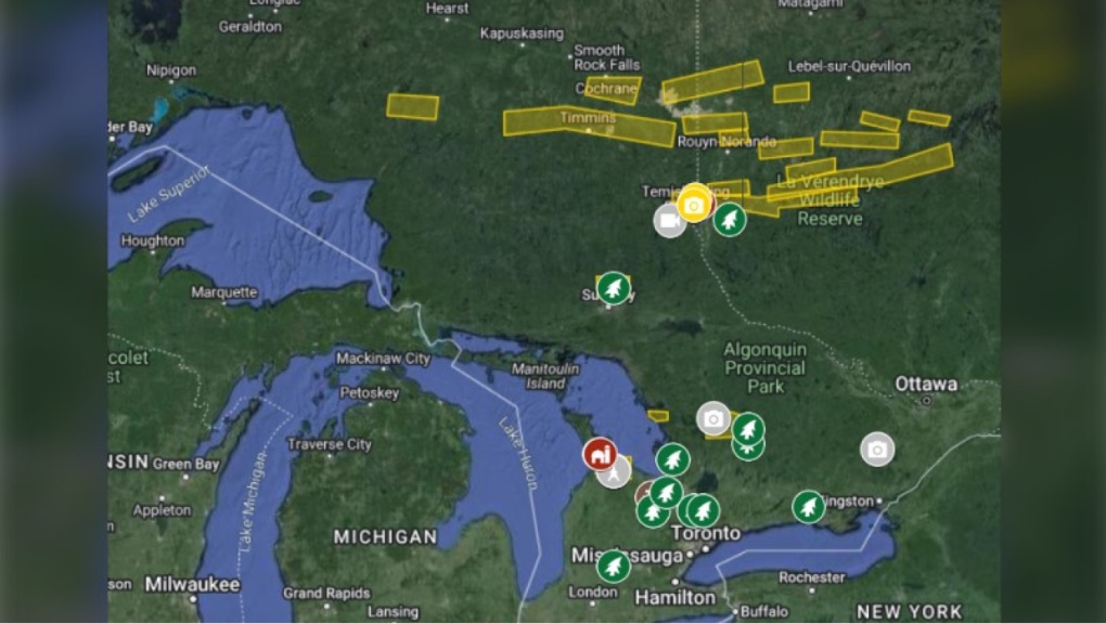
In addition to damage reports on the ground, he said his team has more than a dozen areas to look at for potential tornado activity in the satellite imagery.
“We’ve got a lot of work ahead of us trying to figure out which storms produced damaging winds and tornadoes and which didn’t,” Sills said.
Tornado researchers use planes and drones to get extremely detailed imagery of the storm damage.
 Storm damage being tracked by the Northern Tornadoes Project. (Supplied)
Data provides forecasting feedback
Sills said the information they are receiving through their research is helping to improve the accuracy of weather forecasting.
“It’s giving Environment Canada forecasters feedback on how well their warnings did. Was it a hit? Was it a miss? Was it a false alarm,” he said.
“So it really makes a big difference to know in an area like northern Ontario, a huge area, what is actually happening on the ground. Because for many years, it just wasn’t clear what was happening. So they’d put out a warning and hear nothing back and you know it doesn’t help improve the accuracy, right? That has a big impact.”
The Canadian Red Cross said tornado season is usually between April and September, with the strongest winds in June and July.
Big storms that are capable of producing tornadoes in the middle of summer all the way up to Hudson Bay make getting accurate weather alerts out as soon as possible all the more important.
Two tornadoes have been confirmed in Ontario this month. A category EF2 on June 4 has been confirmed by Northern Tornadoes Project in northwestern Ontario and an EF0 on June 6 in Spencerville, south of Ottawa.
o Download our app to get local alerts on your device
o Get the latest local updates right to your inbox
Meanwhile in New Liskeard, Graydon said while the downburst left some property and vehicle damage in its wake, thankfully no one was injured.
The camp owner said he found so many huge trees were twisted off the ground as a result of the storm that he won’t be able to reopen for at least a week.


)


