World
Heat warnings expanded across the Maritimes, first named storm for hurricane season possible by Wednesday

Environment Canada has placed the entirety of the Maritimes under heat warnings as of Tuesday afternoon.
The criteria for a heat warning is slightly different for each Maritimes province but require two consecutive days and nights of hot temperatures, high humidex and warm nights.
The warnings call for widespread humidex values making it feel well into the 30s and in some cases 40s for the Maritimes. The warnings note that some coastal areas will experience more moderate temperatures.
The weather agency goes on to recommend to “Drink plenty of water regularly, even before you feel thirsty, to decrease your risk of dehydration. Thirst is not a good indicator of dehydration. Watch for early signs of heat illness – feeling unwell, fatigue, thirst, headache – all these can rapidly evolve into life-threatening emergencies. Move to a cooler environment immediately, such as a shaded or air-conditioned space.”
Heat warning criteria for the three Maritime provinces.
Mid-week heat
Parts of the Maritimes are experiencing the first of some unseasonably hot and humid weather Tuesday. High temperatures for much of New Brunswick and interior areas of the southwest of Nova Scotia are expected to reach temperatures in the high 20s and low 30s.
Humidex values, or what it feels like with both heat and humidity, are expected in the mid-to-high 30s.
Both the heat and humidity are expected to reach a peak in the Maritimes Wednesday and Thursday.
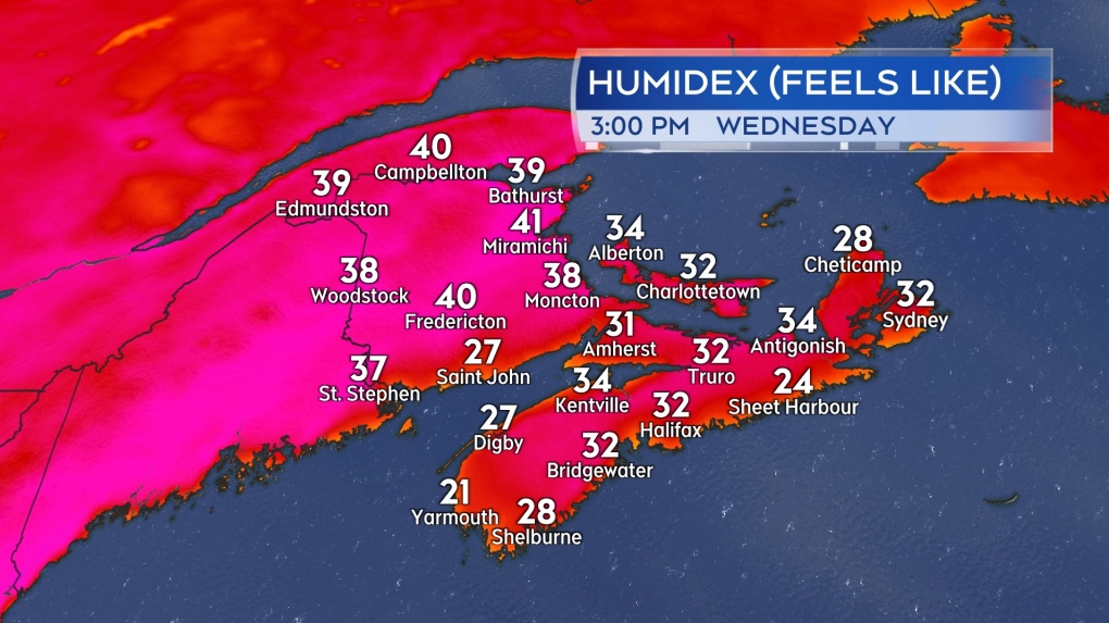
On Wednesday, high temperatures reach high 20s and low 30s across most of the region. Humidex values will make it feel in the mid-to-high 30s with some in New Brunswick into the low 40s. There will be cooler coastal areas, especially the Bay of Fundy coastline of New Brunswick and Atlantic coastal Nova Scotia, where the wind is expected to be more onshore.
 Possible humidex values, or what it feels like with both temperature and humidity, Wednesday afternoon in the Maritimes.
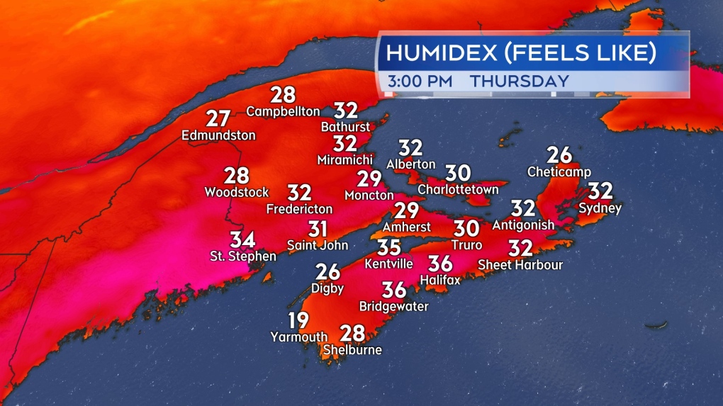
Similar conditions are expected on Thursday with a few exceptions. Once again, areas directly on the coast will have more moderate temperatures as a result of a breeze off the ocean. Additionally, a turn to a northwest wind in northern New Brunswick will start bringing in some slightly cooler and much less humid air. It will still be hot Thursday for northern New Brunswick, but the humidex values could be reduced to the high 20s and low 30s.
 Possible humidex values, or what it feels like with both temperature and humidity, Thursday afternoon in the Maritimes.
Relief Friday into Saturday
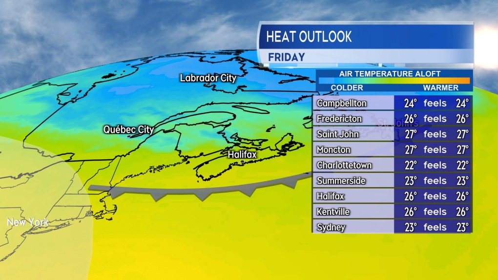
This first round of peak summer heat and humidity doesn’t linger for an overly extended period of time. A cold front is forecast to cross the Maritimes late Thursday into early Friday. Behind the front, some much less humid air filters will arrive from the north and will work to relieve both temperature and humidity levels Friday into Saturday.
Due to the warm, humid air built up ahead of the arrival of the front, as the system moves through, it will bring a risk of thunderstorms. The chance of thunderstorms are highest Thursday afternoon and evening in New Brunswick, Prince Edward Island, and eastern Nova Scotia.
 A cold front brings a risk of thunderstorms to the Maritimes Thursday. Less humid air behind the front will help to relieve the heat and humidity built up for Friday.
Possible first named storm of hurricane season
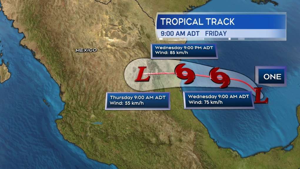
The National Hurricane Center has designated a developing system in the Gulf of Mexico as Potential Tropical Cyclone One. While not a tropical storm yet there is a high degree of confidence it will develop into one by Wednesday. If and once it does, it will be named Alberto, the first named storm of the 2024 Atlantic hurricane season.
The system is forecast to move westward coming onshore in the Mexican province of Tamaulipas Wednesday into Thursday. The system could bring areas of heavy rain to northeastern Mexico as well as parts of southern Texas. Flash flooding and mudslides in higher terrain are common hazards associated with this type of storm.
 The forecast cone for Potential Tropical Cyclone One issued by the National Hurricane Center.


)


