
World
Pressure cooker: Heat warnings triggered in eastern and western Canada

High pressure turning up the heat
Dual, dominant areas of high pressure are contributing to the heat warnings in both eastern and western Canada.
In Atlantic Canada a combination of a ridge of high pressure built out of the eastern United States and a southerly flow are bringing in humid air and high temperatures for many communities. Temperatures are expected to reach the high-twenties and low-thirties. The humidex is making it feel into the mid-to-high 30’s. Heat warnings are in effect in Newfoundland and Labrador, New Brunswick, Nova Scotia, and Prince Edward Island.
In western Canada a high pressure system centred near Wyoming is helping to send temperatures soaring. The clockwise circulation around the high cycling in air from the hotter states such as California, Nevada, and Arizona. High temperature records fell by the dozen on Sunday for British Columbia, including at Ashcroft to the west of Kamloops which reported a high of 40.3 degrees. Southern and eastern areas of that province remain under Heat Warnings on Monday. Heat Warnings have also expanded across Alberta and into Saskatchewan as well as touching into the Northwest Territories.
High pressure helping to pump hot, humid air into Atlantic Canada. In the west a similar situation with a ridge of high pressure building out of the northwestern US.
Mid-week cooling for the Maritimes
The heat is expected to last through Tuesday with changes arriving Wednesday into Thursday. A weather front from the west will increase cloudiness and return rain and showers to the region with temperatures coming down as a result. Despite the cooling humidity is expected to remain high for all three Maritimes provinces, especially with the contribute moisture from the rain and showers. Expect muggy conditions to continue into the upcoming weekend.
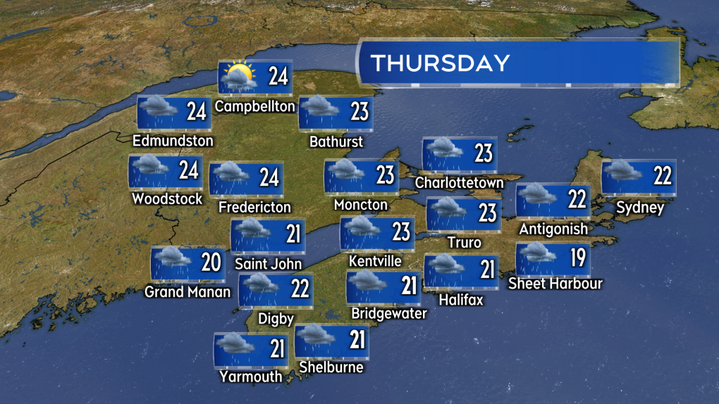 Humidity remains high but temperatures cool Wednesday into Thursday for the Maritimes.
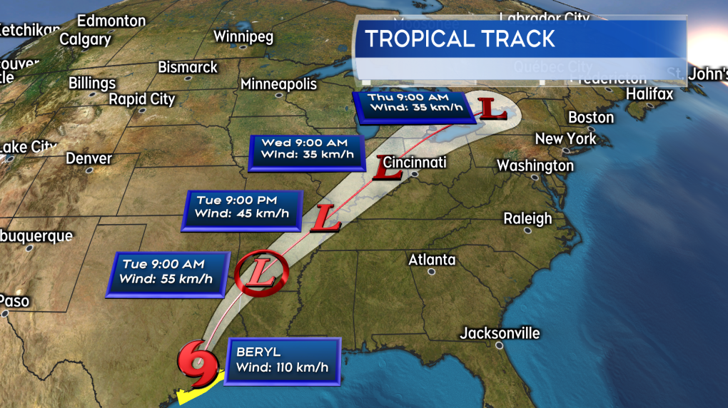
Remnants of Hurricane Beryl
Beryl has come onshore in Texas as a category-one hurricane. The storm continues to poses risks associated with storm surge, rip tides, flash flooding, and high winds to that state.
Beryl is forecast to move from Texas into the US-Midwest by Wednesday. While weakening and becoming non-tropical along the route, remnants of Beryl is likely to get tied up into the front bringing the Maritimes rain this week. This increases the risk of downpours and thunderstorms within the rain expected.
 Beryl becomes a remnant weather system as it moves through the US this week. The leftover moisture from the system may bring a risk of downpours to parts of the Maritimes late Wednesday and Thursday.
At this time the area and period of time of greatest risk is southern New Brunswick and mainland Nova Scotia late Wednesday through Thursday. The stalling front acting like a highway to send the downpours along. With Beryl having to travel through the United States it is too early to look at possible rain totals for specific areas/communities at this time. Computer weather prediction models are indicating pockets of rain totals 60 to over 100 mm being possible though. A situation that will need to be watched moving later into the week.

20/7/2024 Horse Racing Tips and Best Bets – Rosehill, Winter Challenge day
 "BCCI want Test specialists to play domestic cricket; Rohit, Virat, Bumrah to be exceptions")
BCCI want Test specialists to play domestic cricket; Rohit, Virat, Bumrah to be exceptions

HORSE RACING DAY 5: Andrew Champagne’s picks, analysis, bankroll
HORSE RACING DAY 5: Andrew Champagne’s picks, analysis, bankroll

600 Jobs, 25,000 Seekers: Air India Drive Sets Off Stampede Fear In Mumbai

More Trips, Higher Prices: Business Travel Spending May Finally Top 2019 Levels

Let’s take this offline: why indie fashion boutiques are back in fashion

Blue Jays balance college-heavy Draft with a few high-upside picks

Get to Know Gopher Men’s Basketball’s Frank Mitchell – University of Minnesota Athletics
